


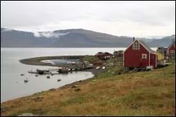
Upernavik Kujalleq is located some 81 km south of Upernavik. The settlement is often referred to as Søndre Upernavik, meaning southern Upernavik, and its Greenlandic name means exactly this. The settlement was founded as a trading station in 1855 and it is relatively green as opposed to most other major settlements in the area. It is located in a flat landscape with plenty of remaining capacity for future development. The settlement is situated on the eastern side of a small tongue of land of one of the major islands in Baffin Bay.
Provisions and subareas
The general provisions apply to all subareas of the municipalities in towns, settlements and open country areas. The provisions are general and do not consider the local conditions in the subareas.
General provisions of the Town Plan
The overall provisions for each subarea are the basis for the municipality"s granting of area allotments and building permits.
The aim is to maintain the current level of service and housing. Further urban development is to take place within the existing settlement area.
The aim is to develop both fishing and possibly tourism in cooperation with other dwellings, and areas are to be zoned for trades to cooperate across disciplines. In particular, there is need for better quay facilities, and the area by the lake may be used for port purposes. In general, the housing stock is in dire need of rehabilitation and redevelopment, and better waste management is required in order to boost living conditions in the settlement.
There are plenty of activities for children and youth, both in the settlement and in the nature surrounding it, and these can be utilised for learning and for improving association activities. The citizens want to protect activities such as dog sledging and the traditional sealing and whaling culture, so the settlement is to secure room for these elements.
Since 1980, the population of Upernavik Kujalleq has grown from 133 inhabitants, to 195 inhabitants in 2017. However, in the past 20 years, it has been relatively stagnant, showing only minor fluctuations in population growth. The settlement has a relatively large share of children and youth (36 per cent), and this figure has been stable seen across a longer period of time.
The housing stock in Upernavik Kujalleq mainly consists of detached single-family houses, many of which area outdated in terms of size and condition. Upernavik’s settlements tend to have large household sizes (up to eight or nine persons) despite the very small houses. In Upernavik Kujalleq, the average number of persons per. household is 4.4, which is the second highest in the settlements around Upernavik. Consequently, there is a need for both expanding the housing stock and redeveloping/rehabilitating the existing homes. The remaining residential capacity of the settlement is estimated at 40 homes.
The primary trades of the settlement are fishing, sealing and whaling, but fishing has seen a decline in recent years because of a limited population of Greenland halibut. Royal Greenland and Polar Seafood A/S merging into Upernavik Seafood A/S also resulted in the factory facility closing. However, it is still possible to trade fish in Upernavik Kujalleq.
The port is located in the central part of the settlement and features a small pontoon port, which includes a three-metre jetty for fishing dinghies. The water depth is two metres. A nearby lake may possibly be used for port purposes. Off the harbour dock, Naalakkersuisut has designated the surrounding area as a port authority area.
Furthermore, Upernavik Kujalleq has been designated a supplementary supply base for the license blocks in Baffin Bay. It was chosen because of the island’s large, flat areas near a relatively protected bay and because of its proximity to Upernavik, which is designated a main supply base. The settlement has the potential to act as a major storage area in connection with both exploration and expansion phases provided that a new port be established. Navigation conditions are good, and the settlement is navigable from May to December. A new area north of the settlement has been zoned for industry and port purposes.
The settlement also holds the following functions, which employ the majority of the population: Pilersuisoq, Qaasuitsup Municipality, the school, Nukissiorfiit, Saattuaq A/S, the church and the settlement consultation post. Jobs are also related to tourism. By 2015, the unemployment rate in the rural areas of the Upernavik district was 10.9% overall. This is slightly higher than Upernavik, where the unemployment rate was 9.3%. Likewise, it is slightly higher than both the municipal average (9.1%) and the national average (9.1%).
In the town plan, the remaining capacity for industry and port facilities is estimated at 32,000 m².
The settlement’s helistop was recently moved from its original location by the church to the north-western part of the settlement. Other transport is by sea, by dog sledge or snowmobiles, depending on ice conditions.
The road structure in the settlement actually consists of just two roads: An east-west running road that links the settlement to the dump and the incineration plant towards the west, and a north-south running road from the church in the south to the industrial area (former Royal Greenland production facility) in the north.
The technical operation is handled by Nukissiorfiit, and telecommunication is handled by TELE Greenland A/S. The settlement is not sewered, and grey wastewater is discharged directly above ground. Night soil is collected in bags and deposited by a ramp where it is emptied directly onto the beach. Water supply is generated via the osmosis plant located by the settlement’s power plant just east of the cemetery. Water is collected at bottling houses. In general, the water level is low and water replacement is poor.
Upernavik Kujalleq boasts two senior homes and a settlement consultation post, a settlement office and a library. There are no organised child-care services.
The school, Mathiarsip Atuarfia, has approx. 40 students divided into 1-9. grade. Pupils take form 10 in Upernavik.
The settlement’s oldest buildings are located in the area by the port, and it includes a total of seven preservation-worthy buildings: B-73, B-75, B-77, B-79, B-80, B-119 and B-120. However, the preservation-worthy buildings are in need of general rehabilitation.
The church is located in the southern part of the settlement, thereby marking the settlement’s border to the south. The church, the youth club (Johannes-ip Katersortarfia) and the village hall form the basis for the settlement’s cultural and association activities.
