


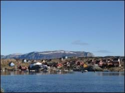
Saattut is the largest settlement in the Uummannaq area, located some 26 km northeast of Uummannaq. Its name means “thin, flat rocks”, which is also the name of the little island that it is located on, in a relatively flat rock terrain. The area is characterised by a lot of islands with high mountains, less than 30 km from the glaciers of the inland ice.
Tourists visiting the settlement find private accommodation and experience first-hand the Greenlandic culture – the food, sealing, whaling, fishing and the daily life of an average Greenlandic family.
Provisions and subareas
The general provisions apply to all subareas of the municipalities in towns, settlements and open country areas. The provisions are general and do not consider the local conditions in the subareas.
General provisions of the Town Plan
The overall provisions for each subarea are the basis for the municipality"s granting of area allotments and building permits.
As a minimum, the current level of service and housing in Saattut is to be maintained. The goal is to continually develop and strengthen fishing and tourism. The industrial areas are to match the demand, including quay facilities and infrastructure. It is important to establish an actual assembly facility in the settlement that provides the facilities needed (e.g., by the school or the church), and likewise the older buildings should be integrated in community functions, e.g. boat workshop etc.
In January 2017 there were 240 inhabitants in Saattut. Population numbers fell from 292 in 1977 to 234 in 1990 and then expanded until 2001, where 283 people lived in the settlement. The population is estimated to remain stable in the future, so the current areas zoned for residential purposes are maintained, and rehabilitation and redevelopment will also be needed along the way. The remaining capacity of the residential areas is estimated to around 60 homes.
In settlements of Uummannaq district there are 509 homes (2010), mostly detached single family houses in 1-1½ storeys. In 2017 there were 367 households collected in the settlements, with a total of 981 persons. This corresponds to an average household size of 2.7 persons per household, which is the same as in the town of Uummannaq and almost the same as the municipal average (2.8). Quite a few houses are in need of rehabilitation and some are empty.
The primary trade is fishing which is done all year round. Royal Greenland operates a production facility in the settlement, which receives Greenland halibut. The number of employees at the factory ranges from one in the low season to 15 in peak season. Saattut’s quay lies onto a north-facing bay and features a pontoon bridge for small boats. Dinghies are made fast along the north coast and hauled wherever the terrain so permits. Naalakkersuisut has designated a smaller area off the quayside as a port authority area.
Jobs are also related to service facilities: the shop, the school, the municipal functions, sealing, whaling and tourism. The seven settlements in the Uummannaq district had a total unemployment rate of 6.7% in 2015, which is lower than for the town Uummannaq (7.8%). The Uummannaq settlements, as well as the Ilulissat settlements, both have a total unemployment rate of 6.7%, which is Avannaata Kommunia's lowest. The unemployment rate is therefore also lower than both the municipal average (9.1%) and the national average (9.1%).
In the town plan, the remaining capacity for industry and port facilities is around 13,000 m².
The settlement is serviced by a helistop south of the settlement. Other transport is by dog sledge and snowmobile.
The settlement has no actual system of roads, rather wheel tracks that run from the central district around the school and church to the port in the northern part, and through the western part to the hauling site and further southwards, passing through residential areas on to the helistop. Many roads are more like paths.
Overall technical operation is handled by Nukissiorfiit. The settlement features a power plant, and the water production is based on a desalination plant and collection at a bottling house. Heating is provided by private oil burners. Day-time refuse is deposited and burned at the dump just east of the port. The settlement is unsewered, and night soil renovation is discharged into the sea from a little, worn-down wooden ramp. Telecommunications is handled by TELE Greenland A/S. Telephone pole and telecommunications hut are located on the southern edge of the island.
Saattut also boasts a municipal office, a nursing station, a community workshop, a KNI shop, private kiosks, a service house and a village hall. It has no hotel, but private accommodation is possible. There is no retirement home, so senior citizens in need of such facilities have to move to town. There is also a kindergarten with room for 24 children.
The settlement has a primary school (Muusap Atuarfia) which has approx. 30 students in the 1st to 9th grade and a small library. The school also hosts recreational club activities.
The settlement includes the following preservation-worthy buildings: (B-90) school – former shop – built in 1899, (B-94) storehouse from 1878, and (B-99) storehouse – former blubber processing house – from 1871, (B-101) midwife consultation post from 1905 and (B-131) church from 1927. Some of the buildings have suffered brutal rehabilitation, but may be able to constitute a historical building environment in the centre of the settlement.
Built as a school chapel in 1927, the church was fitted out as an actual church in 1980. The cemetery is located a couple of hundred metres south of the settlement. Other cultural and leisure activities use the premises of the school and the village hall. The southern part of the settlement also includes a playground.
