


On Saturday, June 17, 2017, there was a landslide in Karrat Fjord. The landslide triggered a tsunami. Residents of both Illorsuit and Nuugaatsiaq are currently relocated at other locations.
For further information, please refer to information from the Department of Nature and Environment: emergency_assessment.pdf (281.7 KB) (danish only)
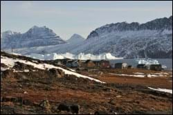
Nuugaatsiaq – “the medium-sized protruding point” – is located on a grassy promontory on the south coast of Qeqertarsuaq Island in the Karrat Ice Fiord, some 130 north of Uummannaq. It is the northernmost settlement in the Uummannaq district, its closest neighbouring settlement being Illorsuit, some 35 towards the southwest.
Provisions and subareas
The general provisions apply to all subareas of the municipalities in towns, settlements and open country areas. The provisions are general and do not consider the local conditions in the subareas.
General provisions of the Town Plan
The overall provisions for each subarea are the basis for the municipality"s granting of area allotments and building permits.
As a minimum, the current level of service and housing in the settlement is to be maintained. The goal is to strengthen and further develop fishing and tourism. This calls for room for extending the factory and possibly skin trading as well as improving quay facilities. At the same time, the housing standards, refuse collection schemes and infrastructure should be improved, based on the needs and resources of the settlement. Dog sledging plays a large role in the settlement and should be possible in the future. The flat areas of the settlement are to be used for recreational purposes.
The population in Nuugaatsiaq counts 102 people in 2017. The settlement grew until 1999, where the it peaked with 122 inhabitants; from here it fell to 77 people in 2012. Between 2016 and 2017, there was a significant increase in population from 79 to 102. Consequently, the planning period will primarily call for replacement buildings in connection with redevelopment. Senior housing is also in demand, but care-requiring senior citizens should be handled at Uummannaq’s facilities.
The settlements of Uummannaq total 509 homes (2010 figures), primarily detached single-family houses in one to 1½ storeys. In 2017, the settlements numbered 367 households and a total of 981 inhabitants. Nuugaatsiaq has the largest average household size in the district with 3.3 persons per household. Quite a few houses are in need of rehabilitation and many are empty.
Future houses are to be established in continuation of the existing houses. The remaining capacity of the existing areas is considered fine, corresponding to some 70 homes.
The primary trades used to be sealing and cat fish fishing, but Greenland halibut fishing has surpassed them. Fishing for Greenland halibut is of major financial importance to the inhabitants. Royal Greenland operates a trading facility in Nuugaatsiaq where the fish is processed and frozen. Fish is traded all year around, but the freezing capacity is sometimes insufficient during the winter/spring when sea ice prevents ships and dinghies from exporting the frozen fish. The production facility employs between one and ten persons, depending on the season.
The season has a small quay at the very edge of the promontory. Boats are made fast in the bay and hauled onto the beach in a small bay east of the promontory. However, further port facilities are needed. Naalakkersuisut has designated the area off the quayside as a port authority area.
Jobs are mainly related to fishing, but the shop, the school and the other municipal functions also generate jobs as do tourism activities. The seven settlements in the Uummannaq district had a total unemployment rate of 6.7% in 2015, which is lower than for the town Uummannaq (7.8%). The Uummannaq settlements, as well as the Ilulissat settlements, both have a total unemployment rate of 6.7%, which is Avannaata Kommunia's lowest. The unemployment rate is therefore also lower than both the municipal average (9.1%) and the national average (9.1%).
In the town plan, the remaining capacity for industry and port facilities is around 12,000 m².
The settlement’s helistop is located just north of the settlement. Other transport to and from the settlement is primarily by dinghy in the summer, and dog sledge or snowmobile in the winter.
The infrastructure includes a paved road section on the promontory and near the port and production facility. There are also wheel tracks, which run up the promontory and branch out to the western and eastern parts of the settlement.
The overall technical operation is handled by Nukissiorfiit. The power plant is located easternmost in the settlement. In the winter, water supply is provided by a water tank and a bottling facility near the service house in the settlement centre. In the summer, water is collected from a creek to the east. Day-time refuse is deposited and burned at the dump west of the settlement, although the access conditions are poor. The settlement is not sewered. There is no night-soil scheme, and night soil is dumped into the sea from a ramp by the promontory – an unsuitable location. The promontory also features tank installations next to the fish factory and the quay. The tank installations are covered by a protection zone. Telecommunications is handled by TELE Greenland A/S.
The settlement has no child-care institution, so child care is handled by means of family day care. It also boasts a shop, a municipal office, a community workshop, a post office, a nursing station and a village hall. School and service functions are located on the promontory.
Atuarfik Saamu elementary school numbers around 15 pupils in forms 1 through 9. The school organises recreational club activities and also features a small library.
Dating back to 1991, the school chapel is located in the northernmost part of the settlement, next to the cemetery.
The oldest buildings in the settlement are situated on the very edge of the promontory. The preservation-worthy buildings include: B-83, warehouse, built in 1924; B-84, warehouse, built in 1936; B-86, shop and office, built in 1930, extended in 1989; B-87, warehouse, blubber processing house, built in 1850, relocated from Nugssuaq; B-89, warehouse, unknown construction year. The buildings are located near each other, making up a preservation-worthy building environment high on the promontory. The area is visible from the port and characterises the urban scene of Nuugaatsiaq. Following permission by the Greenland National Museum, the buildings may be dismantled and relocated.
The even terrain in the middle of the settlement is used for soccer, and you can do winter sports in the terrain north of the settlement.
