


Upernavik is one of the northernmost towns in the municipality. Upernavik means “the springtime place”, since this was where you went in the spring when the ice broke to trade, fish and catch seals and whales in the open sea. Upernavik is located in Baffin Bay on Upernavik Island in the southern part of Upernavik Ice Fiord. The town was the principal town of the former Upernavik Municipality and has ten settlements. Officially, the town was founded as a colonial station in 1772, but has acted as a dwelling since the 17th century.
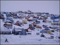
The town is located on the southern part of the island, and the townscape is characterised by colourful single-family houses bordering on the mountains. The public functions and industries are mainly located by the sea. Farthest to the south is the oldest colonial buildings, and the centre area is farthest to the west. In recent years, a new cultural centre was added to the northern town district, which also features a new cultural centre, a new dormitory and new outdoor sports facilities. The new centre area is the start of further urban development towards the north.
Provisions and subareas
The general provisions apply to all subareas of the municipalities in towns, settlements and open country areas. The provisions are general and do not consider the local conditions in the subareas.
General provisions of the Town Plan
The overall provisions for each subarea are the basis for the municipality"s granting of area allotments and building permits.
In 1772 Andreas Bruun founded the colony Upernavik on the southern part of Upernavik Island, where the sea was always calm, regardless of the weather. Upernavik was the place that was reached in the spring when the ice broke up; partly to trade and partly to fish and hunt by the open sea, hence the name of Upernavik ("Springtime Place").
For the already settled First Nation People, it became the transition to a whole new community. But the Danish residents of the colony suffered from cold and hunger when ship supplies were absent, and several times the Danes left the colony again. In 1823 the trade was restored in the district, and Upernavik was got status as a trading station under the colony of Godhavn (Qeqertarsuaq) before it became an independent colony in 1826.
Commerce was based on the traditional hunting and fishing. Seals, whales, fish and birds were the main ingredient of the people's food, and clothes were made of skins from various animals. An important wildlife was the guillemot, which today still breeds on two very rich bird cliffs in the area. Both the birds and their eggs were used as food. Around 1920, fishing for halibut started, but fishing didn't reach a large scale before well into the 1980s so Upernavik was called a fishing community.
Due to the very sparse archaeological activity in the area around Upernavik, there is very little knowledge about the first stone age cultures in the area. There have only been two organized excavations, but in contrast, many of the former winter-homes from the Thule culture are still visible in the landscape. On Upernavik Island there are several ruins, and it is possible by boat to visit several former settlements from the 17th and 18th century.
The town is to continue to develop as a local town offering primary supplies of public and private services, including for its ten settlements.
Fishing and fish production are the dominant trades in town, and Upernavik has a great basis for establishing both training programmes, courses and innovation regarding fishing, as well as expanding fish production to cover more species, which may generate more as well as more permanent jobs. Development possibilities are to be supported by means of sufficient and suitable zoning of areas, satisfactory supply of water, sewerage etc.
Furthermore, areas should be allotted to different land-based trades and tourism. Port facilities and water supply are of high importance to the development potential, and extension possibilities should be looked into. Improvements of the water supply will also call for expanding the sewer system.
One of the main priority areas in Upernavik, in addition to fishing, is the potential offshore-related activities and the town’s status as a main supply base for the oil exploration in Qaasuitsup Municipality. The town plan enables further development, including port, industry, infrastructure, houses and centre purposes – both in the northern part of Upernavik Island and on large parts of Akia Island in the long term. In terms of area, Akia Island has the potential to house a new runway and a new, larger port including storage and industrial areas. In the long term, a fixed connection may be established between Upernavik Island and Akia Island.
One of the main priorities is to carry out a coordinated study and mapping of the possibilities for expanding urban areas and infrastructure, including roads, heliport and helicopter hangar, and finding a new location for the dump.
As the principal town for nine settlements, children and youth, culture and education play a key role, and improving the basis for these elements – not least dormitories – will also benefit the settlements. Residential development is to be considerate and respect the existing houses, which are primarily made up of single-family houses.
The municipality’s overall vision and objectives guide the physical development along with the citizens’ wishes. Consequently, the outcome differs across towns and settlements as shown here:
actions_upernavik.pdf (744.1 KB)
In 2013, there were 1,181 inhabitants in Upernavik, distributed over 396 households, corresponding to an average household size of three persons. The population has increased steadily since 1980 (844 persons), growing by almost 40 per cent in 2013. The population trend has seen vast fluctuations in the past decade. Previously, the younger generation made up the majority of the population, but the number of children and youth has gone down considerably in recent years. Immigration is mainly made up of people from Nuuk, Sisimiut and settlements.
The town includes 392 homes, of which only 21 are not single-family houses, but semi-detached houses. Upernavik has no multi-storey residential buildings. The houses are in general need of maintenance and modernisation.
The town plan includes a large remaining capacity, since new, large areas are zoned for residential, centre, industrial and port purposes north of the existing town area, and large areas are also zoned on Akia Island, some 800 south of Upernavik Island. The remaining residential capacity in town is estimated at 860 homes in a new urban development area north of town.
The main trade in Upernavik is Greenland halibut fishing, and the inhabitants also catch seals, narwhals, belugas and polar bears.
For a number of years, the overall industrial policy has been to support the transition from sealing and whaling to modern fishing, as well as processing and export of fish products. Today, this transition is almost complete and has been followed by investments in production and freezing facilities, which, unfortunately, have suffered from factory closures and declines. Upernavik’s limited water resources pose a barrier to the fishing trade and limit the possibilities of developing other types of production. Consequently, a better water supply is required.
Upernavik features a container port with a quay length of 30 metres and an adjoining container area. It also features a schooner port with a schooner jetty, which has a 15-metre quay and a water depth of 4.2 metres. There is a wish to add a breakwater to the container port, since the port suffers heavy swells. Before the existing port facilities are extended, further studies are to be carried out to uncover concrete possibilities and current conditions.
Furthermore, Upernavik was designated one of two main supply bases for offshore activities for the oil industry. In this connection, vast areas have been zoned for developing the town’s infrastructure, including a port extension featuring new quay and port areas. If the demand for an even bigger port should arise, the town plan zones areas on Akia Island (800 metres south of Upernavik) for the construction of a new port, including areas for storage and industry. Akia Island offers better water supply than Upernavik.
In 2000, the airport in Upernavik opened, located on top of the island’s characteristic mountain top, creating better connections to the outside world while creating the basis for increased tourism in the town. Similarly, cruiser tourism has also increased considerably, making tourism one of the new main trades in Upernavik. Specifically, a number of places providing overnight accommodation have been established along with a tourist office and a sea kayak rental. A range of excursions and activities within the area and the settlements are available. Any future development will relate to experiencing nature, the sealing and whaling environment in the settlements, kayaking and dog sledging. In the settlements, the special settlement culture plays a huge role, and trading of skin and own production may help strengthen the local economies.
Upernavik is also a transit site for flights to Qaanaaq as an outward/homeward journey site for other Greenlandic locations. This gives the town a special role in terms of combination trips.
In the town plan, the remaining capacity for industry and port facilities is estimated at 2,367,000
Upernavik Airport is located at the centre of the island, at a short distance from the town centre. The airport offers regular connections to Ilulissat and Qaanaaq. The settlement helicopter used for district flights uses the airport for schedules flights, whereas the old helistop by the port is still used as a technical base for the helicopter. The zoned area on Akia Island south of Upernavik Island may, in the long term, hold a new runway of up to 2,200 metres, if needed.
Other transport is by sea, by means of dog sledges or snowmobiles. The area offers no passenger boat service as such.
Apart from the newest roads on Telebakken and the road to the airport, the system of roads mainly consists of old wheel tracks and work roads, rather than actual roads. Recent years’ urban growth has entailed a large need for improving and extending the road network. In connection with further urban development towards the north, plans have been made to establish a future road structure that links the new town area to the existing town. Upernavik has no pavements, and few places offer paths or mountain steps.
Power, water and heat supply are handled by Nukissiorfiit, whereas telecommunications is handled by TELE Greenland.
Water supply in Upernavik is based on water catchment from the lake on Upernavik’s east side. From the pump station, water is led through a crude-water pipe to the waterworks. No water distribution network supplies the consumers, so all water is delivered by tanker truck. The town holds very limited water resources, which is considered a significant limiting factor for future urban development. Consequently, efforts are being made to establish a new, more stable water supply from Akia Island.
Only the hospital, the retirement home and the dormitory are sewered. A few households have a sludge tank for black wastewater, and the remaining households are covered by the municipal collection of night-soil bags. The new town district north of the town is to be fully developed, which also means establishment of sewer system. Plans also exist to sewer a few places in the existing town. All wastewater – grey and black – is discharged untreated to the sea from a short ramp by the dump.
The dump is located just south of the old district, generally causing odour problems in town. As a consequence, a new dump area has been zoned north of the town in order to relocate the existing dump as soon as possible.
The centre area of the town is located in the western part, south of the port. The area around Kongepladsen square makes up the central square. In this area, you find the majority of the town’s service functions such as, e.g., the hospital, the municipal office, the shop, the retirement home, the dormitory, the Tele-Post (combined telephone shop and post office), the fire station, the school and various institutions. The town boasts a KNI shop that offers bank services, and two small kiosks.
Upernavik Hospital offers a total of 14 beds, and acts as health-care centre in the Avannaa region as well as part-time dental clinic. The hospital also covers the nine settlements of Upernavik.
The town also includes a retirement home, four senior homes, two group homes for the mentally disabled, and a home-help system.
As to institutions, the town includes a kindergarten with around 65 places, family day care with 32 places, a day nursery with 24 places, and a children’s commune, which is a 24-hour care centre/children’s home with six to eight places.
The elementary school, Prinsesse Margrethe skolen, can hold around 300 pupils in forms 1 through 10. The highest forms (9 and 10) also include pupils from the settlements, who live at the dormitory or with foster families. The school also features a library, which acts as the main library of the settlement libraries.
In 2008, the new dormitory, Piareersarfik kollegiet, was inaugurated. The dormitory is located near the cultural centre in the northern part of town. The town also includes a dormitory for 48 pupils from the settlement, although it is in need of maintenance and possibly extension or new building.
The heritage area in Upernavik covers the old colonial buildings on the south edge of town: Six listed buildings as well as the community centre (B-1191) from 1992, and a peat house (B-1393) constructed in 1997 in honour of Upernavik’s anniversary. Originally, the community centre was to be used for association activities, but is today primarily used for child care and meeting room. The listed buildings include the old church (B-3), the old bakery (B-11), the factor’s residence (B-12), the old shop (B-14), the vicarage (B-98) and the old school (B-99). All listed buildings have been given new use, acting today as, e.g., a museum, a tourist office, exhibition facilities etc.
Outside of the colonial area, a number of individual buildings are designated listed or preservation-worthy, including the church (B-96) and the chapel (B-97), which are both listed. The preservation-worthy buildings include: The clerk’s residence (B-10), the blubber processing house (B-32), the medical officer’s house (B-4), the ship master’s house (B-17), the trade office (B-21), the warehouse (B-28) and the smithy (B-31).
The cultural centre in the northern end of town houses sports, school sports, dancing, theatre, concerts, lectures etc. A soccer field is located near the activity house. The two sports clubs in town use the sports facilities at the school for training facilities. In addition, the town includes the Red Barnet Klubhus (Save the Children club house), which opened in 2009.
Upernavik offers plenty of possibilities for unique natural experiences, and the area is known for its 100 small islands where you can go kayaking or power boating. In the winter, the sea around Upernavik is frozen over, so all transport is by snowmobile or dog sledge, to the extent possible.
