


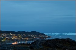
Ilulissat is located on the northern shore of the Ilulissat Icefiord, which leads to Sermeq Kujalleq, the most productive glacier in the northern hemisphere. In Greenlandic, Ilulissat means icebergs, named after the large icebergs running aground on a submerged moraine ridge at the mouth of the Icefiord.
The settlements of Ilimanaq, Saqqaq, Qeqertaq and Oqaatsut belong to Ilulissat.
The oldest parts of the town lie to the north near the town centre, the port and the hospital. Over time, the town has expanded considerably in all directions. Looking onto the ice fiord, the western part of the town contains the large and oldest residential areas, whereas the main urban functions, such as shops, the school, institutions and industrial areas extend southwards from the town centre. The town has also extended towards Hotel Arctic and the airport to the north, the latter replacing the old helistop at Sermermiut to the south. The airport is situated approximately 3.5 km north of the town centre. A special characteristic of the town is the large cross-cutting dog areas with access to the sledge tracks leading to the ice cap.
Provisions and subareas
The general provisions apply to all subareas of the municipalities in towns, settlements and open country areas. The provisions are general and do not consider the local conditions in the subareas.
General provisions of the Town Plan
The overall provisions for each subarea are the basis for the municipality"s granting of area allotments and building permits.
Originally established in 1741 primarily for missionary purposes, the colony of Jakobshavn soon also became a trading station. The colony grew slowly, and by 1900 it had several districts. The trading houses are located on the southern side of the inner port area. From the port, the town climbs the hill and spreads into two parallel small valleys towards Disko Bay. Here the hospital, the vicarage and the schools are situated.
The trading area includes the warehouse, housing, shops, a municipal administration and a day nursery. The oldest buildings in the area are examples of the architectural heritage from colonial time from the mid-1700s up to the 1940s.
Previously, three settlements belonged to Ilulissat, all situated along Disko Bay between the ice fiord and Jakobshavn. Today, the settlements are considered suburbs. Pitoqqik was closest to the colony, sitting in the small inlet south of the indentation of the sea by the church. Illumiut was situated approximately one kilometre further to the south in a valley. Finally, approximately 1½ km from here, Kingigtoq stood on the high tongue of land overlooking the ice fiord.
Due to the short distance between the colony and Pitoqqik, Pitoqqik and Jakobshavn soon grew together, and already before 1920, Illumiut was thought of as a suburb to Ilulissat. As late as in 1952, Illumiut still had its own school. The latest separate census in 1952 showed a population of 132 in Illumiut. With time, Illumiut has been completely absorbed by Ilulissat and new residential areas have replaced the old buildings of the settlement.
Since housing standards in Illumiut were poor and outdated, a number of standard houses were built in the 1950s and 1960s to replace housing in the area towards the old part of Pitoqqik.
Since then, the town has grown, and the area named "the middle town” (by Alanngukasiup Qaava and Kuunnguarsuup Qaava) was the first to be annexed to the town. In recent decades, the town has expanded towards the ice fiord right up to the boundaries of the UNESCO site. Lately, urban expansion has been towards the airport north of the town.
Overall development of the municipality relies on the continued status of Ilulissat as the growth centre of North Greenland. As the principal town in the municipality, Ilulissat is to pursue different development paths. Tourism is undoubtedly the sector with the greatest potential for development, Ilulissat being Greenland's leading tourist destination with a well-developed and robust tourism industry in place. Improving the appearance of urban open spaces and taking advantage of the architectural heritage are important for further developing tourism. However, to keep pace with developments, fishing and the related processing industry still need support and upgrading through zoning of new areas. Another development path is provided by the oil industry, where Ilulissat has been identified as supplementary supply base for oil exploration drilling in the licensed blocks in Disko West.
Furthermore, the town is to cement and further develop its position as a town of education for youth and higher education. The size of the town provides good opportunities for exploiting synergies across educational institutions.
Planning and development focus in particular on extending the airport and building new port facilities to accommodate secondary industries and centre areas in the northern part of Ilulissat. At the same time, areas are to be zoned for new, larger educational institutions, soft businesses, mixed residential areas. Higher building density is to be introduced through coordinated planning. Urban development to the east is restricted by a water protection zone, while the World Heritage Area constitutes a natural boundary to the south.
Finally, emphasis is placed on improving the framework for everyday life in the town, such as indoor and outdoor cultural and leisure activities in the town, not least to enhance local cultural identity and diversity in North Greenland.
The municipality’s overall vision and objectives guide the physical development along with the citizens’ wishes. Consequently, the outcome differs across towns and settlements as shown here: indsatsomraader_ilulissat_uk.pdf (973.4 KB)
Ilulissat is the biggest town in Avannaata Kommunia. In 2017, there were 4,555 inhabitants distributed on 1,736 households. 40 per cent of homes are the property of the Government of Greenland. The population has increased steadily since 1980 (3,648), but has stagnated in the last ten years.
The distribution of dwellings is as follows: 40 per cent single-family houses, 20 per cent semi-detached houses and 40 per cent apartments in multi-storey buildings. Whereas the number of single-family houses and semi-detached houses has risen sharply in the last 15 years, the number of apartments has remained constant. Since 2000, a significant number of student hostels have been built to cater for the many students in town. The average number of persons per household is 2.6.
In recent years, housing development has been concentrated in the southern part of the town and east of the town towards the ice fiord hill and in the areas between the port and Hotel Arctic, where new and larger single-family houses have cropped up. Larger, contiguous residential areas can be developed in the foreland northeast of Hotel Arctic or in areas crossing the water protection zone. Future urban development is mainly to take place to the north or within already existing subareas.
In the town plan, the remaining capacity in Ilulissat is estimated to 270 homes.
The unemployment rate in Ilulissat in 2015 was 7.7% in the town and 6.7% in the associated settlements. The Ilulissat district image is similar to the unemployment picture for the Uummannaq district (7.8% in the town and 6.7% in the settlements). The unemployment rate in Ilulissat was somewhat lower than both the municipal average (9.1%) and the national average (9.1%). In terms of jobs, the biggest trades were public administration and services (853), trade and repair (538). Transport (192) and fishing (190) are almost of the same size. In all, there were approximately 2,235 jobs in the town in 2011.
Industry is concentrated in three locations in the town – around the port, at the foot of the Telebakken to the southwest and north of the quarry southeast of the town. The areas are characterized by heavy industry. In addition, service industries are located in the main street of the town, Kusangajannguaq. The town is short of areas for small entrepreneurs and business owners.
Fishing is the biggest industry in the town. The centre of activity is the port area, which is used for multiple purposes, such as Atlantic quay, factory quay, trawler quay and tourist quay. Fishing is mainly for Greenland halibut and prawns, which are processed, among other places, at the Royal Greenland factory situated in the port area. However, all users of the port need more space, and there is a pressing need for new and contemporary facilities. Naalakkersuisut has designated a port authority area in the outermost harbour area and towards the pier.
Given that Ilulissat is the leading tourist destination in Greenland, tourism is obviously the other major industry in town. The tourism sector has a spill-over effect on the entire town, which translates into a wide range of hotels, restaurants, shops and various services, making it an obvious candidate for conferences. Situated near the main street just south of the municipal office, the tourist offices organise almost all tourist activities, including boat trips, whale safaris, hiking treks, dog sledge riding, cruises, visits to settlements etc. The future development in tourism is highly dependent on the access to modern airport and port facilities, including more international flights and an improved port of call for cruise ships. For some time, the tourism sector and international players have been calling for improved facilities to maintain Ilulissat’s position as an attractive tourist destination. With improved infrastructure and the current supply of tourism facilities, Ilulissat could become the obvious turn-around port for cruise tourism.
The derived impacts would be an increased demand for suitable areas for new hotels, services, etc. Against this background, development of a new urban area is in the pipeline, including centre functions, north of Hotel Arctic.
Another important element of the visions for tourism in the town is the establishment of an ice fiord centre, which is envisioned as a visiting and information centre near Kangia, where tourists and local people can gain knowledge about the ice cap, the Sermeq Kujalleq glacier, climate change etc. A preliminary study of the project has been completed, and work continues to further develop the plans for the centre. The project is expected to be realised based on an architectural competition, and once the detail design is in place, planning is to be supplemented by a town plan addendum with detailed provisions.
In the town plan, the remaining capacity in Ilulissat for industry and port facilities is estimated to 180,000 m².
Opened in 1983, Ilulissat Airport is a medium-sized Greenlandic airport with several daily domestic flights to Nuuk, Kangerlussuaq and Aasiaat and an international route to Reykjavik. For a number of years, discussions have been held on the possibilities for revising the airport structure of the country, including the expansion of Ilulissat and Nuuk airports, to serve as Atlantic airports. the Government of Greenland has, through Kalaallit Airport, initiated both the planning and the actual design of a new airport with the construction of a 2,200 meter runway, new terminal building and associated functions. With the improved conditions and new opportunities for flights to Ilulissat, it is assumed that more tourists will arrive in the town, which will have a positive impact on the development of the town, the municipality and the region.
Ilulissat has a well-developed road network with paved roads stretching from the airport to the north to the old heliport and the outermost residential area in the south. Moreover, the town is serviced by bus. A future extension of the system of roads is to concentrate on Ilulissat North to support the proposed extensions of the airport, port etc. In addition, a ring road is to be constructed, connecting the industrial areas in the eastern part of the town with this area. The system of roads suffers from a number of deficiencies. For example, all heavy goods vehicles have to drive through the main streets of the town and in many places, there are no or only poorly marked pavements.
The town has a network of sledge tracks, which is used for transportation by dog sledges or snowmobiles during winter. The tracks are in need of repair, and crossings need to be made safe. The road network and the sledge tracks are shown on the map of main structures.
The system of paths includes systems of paths/steps and the ordinary road network of which only limited sections have proper pavements. There is an extensive system of recreational paths with a number of marked hiking trails in the hill and along the ice fiord. The recreational hiking paths are connected at the power plant, the quarry and the old heliport.
Nukissiorfiit supplies Ilulissat with power, water and heat, whereas TELE Greenland is the provider of telecommunications based on a number of masts on Telebakken. With the upgrade of the radio line to Ilulissat and extension of the radio link from Uummannaq to Upernavik, only Qaanaaq and a few settlements are not connected to the radio link, but are covered by satellite. Part of the power supply is based on hydropower from Ilulissat’s hydro plant. The 22 MW plant has three turbines and was inaugurated in 2012. The second power plant based on diesel generators is located on the edge of the ice fiord west of the town. In addition, there is a back-up plant next to the fire station in the town centre. Other major plants include tank installations at the entrance to the port, the explosives store west of the dump and the quarry in the southern part of the town, for the time being also accommodating the asphalt plant of the town.
Water supply is based on surface water from lakes east of the town. Heat supply is mainly oil-powered and to a lesser degree powered by residual heat from the incineration plant. Part of the town is connected to the district heating network or to local boiler houses.
Refuse services include day-time refuse and night soil, with day-time refuse being incinerated at incineration plants. Non-combustible waste is deposited in the dump at Nordre Næs by the road to the airport. The dump also receives hazardous waste and metal scrap.
Some domestic sewage is led to the sewerage system and discharged into the sea without further treatment. In areas without sewerage facilities, night soil is collected from households (either bags or sludge tanks) and subsequently pumped into the sea, whereas grey wastewater is discharged onto the side of the hill where it slowly trickles into the fiord.
Public and private services are concentrated in the central part of town, stretching from the trade and administration area along the main street (Kussangajannguaq) to the TELE-POST area. This part of the town has the largest concentrations of shops, post office, cafés, restaurants, discothèques, schools, institutions and municipal offices in the municipality. In addition, there are small, local grocery shops in the individual town districts.
The hotels in town are situated directly at Disko Bay to offer guests the best possible views to the mouth of the ice fiord. Hotels here include Hotel Arctic, Hotel Icefjord and Hotel Hvide Falk. Additional hotels and holiday flats and a couple of youth hostels are dotted around the town. The police station, including the jail, and a number of small businesses are also situated on the coast.
The hospital, which is one of two regional hospitals in the municipality, sits on the outer foreland just by the entrance to the port. Forming part of the Avannaa health region, the hospital is the competent authority for planning and execution of health-care tasks in the region. The hospital has been extended several times and now has a patient hotel and a new surgical section. The town has its own retirement home – Unganartoq Plejecenter Ilulissat – and a dementia centre is in the building.
There are two elementary schools in town – Atuarfik Mathias Storch and Atuarfik Jørgen Brønlund – each covering the entire period of compulsory education from the age of six to 16. The buildings of Atuarfik Mathias Storch's were closed in 2013 and demolished due to mold damage, after which a new school was built and opened in 2017 at the same location as the old school. There are five day nurseries, five kindergartens, day-care facilities, a recreational club for children, before-and-after-school care and a vocational school (Piareersarfik). Also located in Ilulissat is Perorsaanermik Ilinniarfik, the Greenlandic College of Social Education, which offers a variety of social education programmes. Approximately 200 students are enrolled at the college.
Ilulissat has two preservation-worthy areas of special interest (section-2 areas) – the trade and administration district, and the church and museum district.
Bordering the port, the trade and administration district was the first trading district in the town. It illustrates the architectural heritage from the 1700s up to the 1950s and still plays an important role as the municipal administrative area in the town. The district has a number of old buildings dating back to colonial time – supply stall (B-15), colonial factor's residence (B-7 and B-25), clerk's residence (B-8), warehouses (B-9, B B-20 and B-26), residence of the trade manager (B-10), KNI buildings (formerly Greenland Trade) (B-11 and B-93), the present art factory (B-31) – and newer administrative buildings of uniform design by Danish architect Henning Larsen: the municipal office (B-963 and B-964) and the day nursery (B-750). Warehouses B-13 and B-20 have been dismantled and stored for later rebuilding, if feasible. Today, the previous residence of the trade manager (B-10) has been turned into an art museum. Most of the buildings are preservation-worthy; see also the map of main structures.
The church and museum area sits on the fiord directly south of the hospital. The area is an extensive valley scattered with houses, including the characteristic Zion Church (B-75) and the town museum of Ilulissat (B-78), originally the vicarage and parental home of Knud Rasmussen. The chapel (B-76), the new vicarage (B-4), the doctor's residence (B-6) with hen house (B-5) and the old school (B-79, now church office) are also located in the district together with a number of large single-family houses, including greenhouses and gardens of the types 513 and 514 (B-96, B-98 and B-99). The Zion Church (B-75), the museum (B-78) and the chapel (B-76) are listed according to the Greenland Parliament Act no. 11 of 19 May 2010 on listing and other cultural heritage preservation of cultural relics and monuments, cf. the map of main structures. The Qoorunnguaq path (vicar’s path) is an important part of the cultural heritage environment.
Outside the heritage areas, preservation interests relate to the old hospital (B-3, now patient hotel) and Naalakkatta Illua / Qullissat Church (B-987).
The cultural and leisure facilities of the town include a library, a village hall, the culture centre Sermermiut, Ilulissat sports centre and soccer field, all located in the town centre near the TELE-POST area and Pisiffik supermarket. Evening classes are organised at schools, and a wide number of clubs offers activities either at own premises, in the sports centre or in gymnasiums. Finally, Ilulissat offers cross-country skiing in track-set trails, snowmobile driving, dog sledge riding during winter and hiking in the hills almost all year round.
