


Qaarsut – “naked mountain”/”rock surfaces” – is located on the north side of the Nuussuaq peninsula some 25 km northwest of Uummannaq Island and has a view of the island.
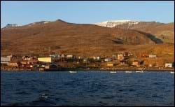
Most of the population are fishermen and hunters. The Greenlandic name means “the naked mountain” and refers to the settlement’s location at the foot of the almost 2,000-metre high Qilertinnguit mountain. The settlement was granted status as trading station around 1870, and Greenland’s first coal mine was in operation in Qaarsut from 1778 to 1924.
Provisions and subareas
The general provisions apply to all subareas of the municipalities in towns, settlements and open country areas. The provisions are general and do not consider the local conditions in the subareas.
General provisions of the Town Plan
The overall provisions for each subarea are the basis for the municipality"s granting of area allotments and building permits.
As a minimum, the current level of service and housing is to be maintained, depending on the development within the offshore industry and the area’s role as a potential supplementary supply base. The goal is also to continue to develop fishing and tourism in the settlement, strengthening the trades, e.g., by realising a trading facility and varied production and by enabling cruisers to call on the port. The dressmaking business and community assembly facilities should also be improved. Furthermore, the wish to relocate the power plant and the interest in sustainable energy should be looked into.
Qaarsut’s current population numbers 171 persons (2017). The settlement population grew steadily from 1980 to 2000, from 198 to 242 persons. Since then, the population has decreased, e.g. due to migration to neighbouring settlements and major towns. In the future, the population is expected to stabilise, and perhaps even increase, as the area is developed as a supplementary supply base for the offshore industry. Consequently, the planning period will primarily call for replacement buildings in connection with development.
Uummannaq’s settlements include a total of 509 homes (2010 figures). In 2017, the settlements numbered 367 households and a total of 981 inhabitants. This corresponds to an average household size of 2.7 persons per household, which is the same as in the town of Uummannaq. The homes in Qaarsut are all detached single-family houses of poor maintenance standard. In the town plan, the remaining capacity is estimated at 50 homes.
Qaarsut’s port and industry area extends along the coast, the primary production buildings being located towards the north and dinghy places towards the south. Next to the boat-site to the south, Naalakkersuisut has designated a smaller area as a port authority area. One of the main trades is Greenland halibut fishing and roe processing. Fish is traded in Uummannaq. Furthermore, seals are caught, and the meat and skin processed. The settlement is also visited by tourists who pop by as part of their stay in Uummannaq or trip to the dwelling by Qilakitsoq.
The new port and industry area north of the airport is unbuilt. The area can be used for a wide range of industrial activities.
The majority of jobs in the settlement are related to fishing, sealing, whaling and the airport, but the municipal private service functions such as the shop, the school chapel, the service house etc. also generate jobs. Since 2010, the settlements of Uummannaq have seen a slight decrease in the employment rate. The seven settlements in the Uummannaq district had a total unemployment rate of 6.7% in 2015, which is lower than for the town Uummannaq (7.8%). The Uummannaq settlements, as well as the Ilulissat settlements, both have a total unemployment rate of 6.7%, which is Avannaata Kommunia's lowest. The unemployment rate is therefore also lower than both the municipal average (9.1%) and the national average (9.1%).
In the town plan, the remaining capacity for industry and port facilities is around 82,000 m².
Qaarsut’s airport – Uummannaq Airport in Qaarsuarsuit – opened in 1999. Its primary function is to operate passenger transport to Uummannaq. From the airport, which is located some two kilometres west of the settlement, it takes around ten minutes to fly to Uummannaq by helicopter, and the airport also has flight connections to Ilulissat and Upernavik. The southwestern part of the settlement features a private helistop. Other transport is by sea with small boats, and by dog sledge, snowmobile and car across the sea ice.
The roads in the settlement are limited and are more like paths, and they mainly run from north to south. There is also Lufthavnsvejen, which runs along the coastline towards the north up to the airport and a large industrial area just north of the airport facilities.
The overall technical operation of the settlement is handled by Nukissiorfiit. The water supply is based on surface water, partly from a creek south of the settlement (in the summer), and partly from a water catchment area (in the winter). Heating is provided by independent oil burners, and the power is generated by a diesel-powered power plant located in the middle of the settlement. The settlement is unsewered, and night-soil collection services have no established facilities, so drums are emptied into a watercourse feeding into the sea. Waste and metal scrap etc. are deposited at the dump, which is located northwest of the settlement.
In the port area and the public area by the school area, you find tank installations and telephone pole, respectively. Telecommunications is handled by TELE Greenland A/S.
Services include a shop, a nursing station, service centre, community workshop and a KNI shop. Child care consists of family day care.
In the settlement there is a school chapel (Atuarfik Kaali) which has approx. 30 students from 1st to 9th grade.
The oldest buildings in the settlement are near the port area and include the following preservation-worthy buildings: A workshop from 1927 (B-63), a warehouse from 1920 (B-67), a warehouse from 1932 (B-69), and the settlement manager’s house from 1928 (B-71). The cemetery lies east of the settlement. The new industrial area north of the airport also includes a number of registered, protected ancient monuments and ruins.
Few kilometres east of Qaarsut lies the Inuit dwelling of Qilakitsoq, where a remarkable discovery was made in 1972: Eight mummified bodies from the Thule culture. The mummies are on display at the National Museum in Nuuk and provide key insight into the Inuit culture 500 years ago. The dwelling is a popular tourist site.
The cultural and leisure activities are centred on the school chapel and the village hall. There is also a soccer field in the southern part of the settlement.
