


Aappilattoq means “the red mountain”. Located around 22 km northeast of Upernavik, the settlement was founded in 1805, but did not become a trading station until 1850. The climate by Aappilattoq is milder than near the outer islands, which means that the sea rarely freezes over, so fishing is possible all year round.
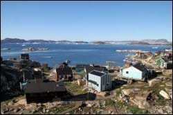
Towards the north and east, Aappilattoq is surrounded by steep, inaccessible mountain terrain. This has limited the possibilities of developing new areas to match the population growth. As a result, the pattern of development is relatively dense and located in a low-lying terrain on the north-western coast of the island.
Provisions and subareas
The general provisions apply to all subareas of the municipalities in towns, settlements and open country areas. The provisions are general and do not consider the local conditions in the subareas.
General provisions of the Town Plan
The overall provisions for each subarea are the basis for the municipality"s granting of area allotments and building permits.
The aim is to maintain the current level of service and housing. Further urban development is to take place within the existing settlement area.
Development is expected within sustainable fishing, among other things because of the interest in establishing a fish production facility (e.g. a factory producing dried strips of halibut). Development opportunities are to be supported through zoning of areas and a study looking into the possibility of improving the existing jetty facilities at the port and, potentially, a port upgrade involving an actual quay. This may make it necessary to relocate major functions (heliport and dump) to more suitable locations. Many homes in the settlement are in need of rehabilitation and redevelopment, and the demand for housing and any new houses should be integrated in existing areas.
The goals for the settlement are to reflect its many children and youth. This means that areas and facilities for children should be given high priority, e.g. soccer field, meeting places and kindergarten, as should teacher housing and drop-in centres. There is also to reserved sufficient areas for traditional activities such as dog keeping.
Overall, the population grew in the period from 1980 to 2017, from 119 to 163 inhabitants. The population peaked around the turn of the millennium with 231 inhabitants in Aappilattoq. After that, the population has declined steadily, with almost 24% fewer inhabitants in 2017. The population is expected to continue to decrease, so the planning period will primarily call for replacement buildings and rehabilitation.
The homes consist of detached single-family houses, which are located in two subareas. A new residential area at the ridge towards the southeast is still unbuilt, and its remaining capacity is estimated at around 60 homes. The housing stock in the settlement is in dire need of rehabilitation.
The main trades include fishing, sealing and whaling, which employ most of the settlement’s inhabitants. The main catches are Greenland halibut and seals, which can be caught almost all year around. Royal Greenland and Polar Seafood merging into Upernavik Seafood A/S has meant that the factory in Aappilattoq is now but a trading facility.
Aappilattoq has no real port, rather a small jetty. Boats are made fast along the low-lying coastal areas by the settlement’s centre area. This area is designated as a the port authority area by Naalakkersuisut.
Jobs in the settlement are related to the municipal office, the school, the church, Pilersuisoq, Upernavik Seafood A/S and Nukissiorfiit, the service house and the settlement consultation post. There is also a private trading facility for fresh skin. By 2015, the unemployment rate in the rural areas of the Upernavik district was 10.9% overall. This is slightly higher than Upernavik, where the unemployment rate was 9.3%. Likewise, it is slightly higher than both the municipal average (9.1%) and the national average (9.1%).
Tourism is a relatively new trade in the settlement, but it has a certain development potential. For instance, dog sledge day-trips are organised from Upernavik to Aappilattoq, or you can take kayak tours to the settlement. The increasing tourism in the settlement forms the basis for further development within sales of local products.
In the town plan, the remaining capacity for industry and port facilities is estimated at 5,000 m2.
The settlement helistop has a gravel runway, and other transport is by the sea, by means of either dog sledge or snowmobile.
In principle, there is only one road in the settlement, which runs westwards from the quay and the trading facility to the heliport in the northern part of the settlement. The road is generally more like a path and is of poor maintenance standard. From the thoroughfare, a couple of small roads/path lead into the residential areas.
The technical operation is handled by Nukissiorfiit, and telecommunication is handled by TELE Greenland A/S. Night-soil collection and waste management are handled by a private company. The settlement is unsewered, and grey wastewater is charged directly above ground. Water is extracted from drinking water lakes and distributed at bottling houses. Night-soil services entail collection of bags, which are emptied into the sea from a worn-down ramp without a chute.
Aappilattoq also boats a municipal office, a service house, a settlement consultation post and a village hall. Child-care services consist of family day care.
The settlement's old elementary school, Paaviap Atuarfia, has approx. 30 students divided between 1st and 9th grade in 2013. The old school building was rehabilitated and extended in 1996, and a new school, Narsannguup atuarfia, was constructed in 2011. The school features an independent library building.
The settlement has five preservation-worthy buildings: B-37, B-40, B-41, B-117 and B-132 (the church). All preservation-worthy buildings are located in the centre areas close to the quay.
The cultural scene and leisure activities mainly use the facilities at the school and the village hall.
