


Innaarsuit is a settlement with 166 inhabitants (2017), located approximately 46 km north of Upernavik. Innaarsuit means “the characteristic cliffs”, and the location was used as a dwelling around 1910-1912. Up until 1950, the settlement only numbered 30 inhabitants, but the population has increased steadily ever since.
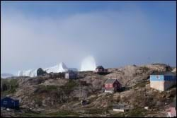
The settlement has developed from the port, which is located in a natural bay on the west coast of the island, where dinghies and small boats are protected from the wind. Near the port, you find the industrial areas as well as a small centre area with the public service facilities. The port and the centre area are encircled by a residential area featuring single-family houses scattered about.
The settlement’s location at the bottom of a hollow has for years hindered its spatial development. A few years ago, a new thoroughfare was establishing, improving the connections to and among the subareas of the settlement.
Provisions and subareas
The general provisions apply to all subareas of the municipalities in towns, settlements and open country areas. The provisions are general and do not consider the local conditions in the subareas.
General provisions of the Town Plan
The overall provisions for each subarea are the basis for the municipality"s granting of area allotments and building permits.
The aim is to maintain the current level of service and housing. Further urban development is to take place within the existing settlement area.
As is the case for the other settlements of Upernavik, the main trades in the settlement include fishing and derived trade, and the settlement is to be able to develop sustainable fishing, including an extension of the trading facilities, and possibly tourism trades. In general, the citizens wish for improved infrastructure, and a road to Natiup Ilua could improve the conditions for businesses. The dump location is unsuitable and it should be relocated. In several places across the settlement, you see waste or old building materials.
The area enjoys a good sealing and whaling environment and the aim is to maintain this culture. The settlement would like to establish several shared functions, and there should be plenty of room for these in the subareas.
Overall, the population has been rising over a 40-year period. In 1977 there were 72 inhabitants, which more than doubled, so in 2017 there were 166 inhabitants.
In the centre area, the remaining capacity for new buildings is limited, so the remaining capacity within this subarea is to be reserved for public/community purposes. A residential zone has been zoned, and its remaining capacity is estimated at around 25 homes.
The housing standard in Innaarsuit is relatively high compared to the other settlements in Upernavik, thanks to recent years’ favourable developments in Greenland halibut fishing.
Trade in Innaarsuit is characterised by fishing, sealing and whaling, and the Greenland halibut trading facility is considered the most important part of the settlement’s business life. Compared to the other settlements of Upernavik, fishing, sealing and whaling account for the largest share of the total income in Innaarsuit. In 2001, trading accounted for as much as 43.2 per cent of total gross income.
The port in Innaarsuit consists of a jetty with a quay length of nine metres and a water depth of two metres. However, the current port facilities are considered insufficient considering the volume of trading and export of catches. The need for larger facilities is also emphasised by KNI Pilersuisoq’s settlement boat services, which make use chartered ships that are larger than ever before. Off the harbour dock, Naalakkersuisut has designated a port authority area, which contains both the water area and the land area at the quayside.
Jobs are related to the school chapel, the branch office, the service house, the settlement consultation post, Upernavik Seafood A/S and tourism. By 2015, the unemployment rate in the rural areas of the Upernavik district was 10.9% overall. This is slightly higher than Upernavik, where the unemployment rate was 9.3%. Likewise, it is slightly higher than both the municipal average (9.1%) and the national average (9.1%).
In the town plan, the remaining capacity for industry and port facilities is estimated at 1,000 m2.
The helistop is located north of the settlement. Other transport is by ship, dog sledge or snowmobile.
The settlement has one primary road connection, which runs from the port and industrial area through the centre area, the eastern part of the residential area, past the dump and helistop in the north, ending at the cemetery in the northwest. In the long term, there is a wish to extend the road from the cemetery down to the centre area, thereby forming a ring road through the settlement and providing better access to the residential area in the northwest.
The technical operation is handled by Nukissiorfiit, and telecommunication is handled by TELE Greenland A/S. Power supply is based on a diesel-powered settlement power plant, and the heat is provided by oil burners. In 2002, a 740-metre water utility network was established in connection with the construction of three new bottling houses and routing of water pipes to the production facility. The water supply is based on surface water. Night-soil services include collection of bags, which are emptied into the sea from a ramp with a chute.
All of the settlement’s public facilities are located in the centre area, covering a service house, a branch office, a settlement consultation post, a chapel and a school. Child-care services consist of family day care.
The primary school of Fiilimuup Atuarfia has approx. 25 students divided between 1st and 8th grade.
Building B-489 in the centre area is designated preservation-worthy.
Innarsuit has no village hall, but the hall in the service house acts as the settlement’s village hall, constituting the overall settings for cultural and leisure activities in the settlement.
