


Kullorsuaq is the northernmost of the settlements of Upernavik. The name means “the big thumb” and is sometimes referred to as “the Devil’s thumb”. The reason for this name is the striking cliff near the settlement, which – viewed from the west – looks like a big thumb. The settlement was founded in 1928, when the first inhabitants immigrated from Qaarusulik – a dwelling some 30 km northwest of Kullorsuaq. Its closest neighbouring settlement to the north, Savissivik, is some 400 km away, and its neighbouring settlement to the south, Nuussuaq, is 70 km away. There are 250 km to Upernavik.
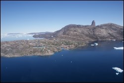
Kullorsuaq is situated on the south-facing areas of a cape around a small natural harbour. Kullorsuaq features a central area with a shop and other services, as well as the port and production facilities. Just west of the settlement centre is the new school. The central area is also encircled by two residential areas, and the settlement’s helistop and dump are located towards the west.
Provisions and subareas
The general provisions apply to all subareas of the municipalities in towns, settlements and open country areas. The provisions are general and do not consider the local conditions in the subareas.
General provisions of the Town Plan
The overall provisions for each subarea are the basis for the municipality"s granting of area allotments and building permits.
The aim is to maintain and expand the current level of service and housing. Further urban development is to take place within the existing settlement area and towards the north where housing may take the form of dense-low buildings, and houses are generally to be of a higher standard. The primarily development of the settlement should be linked to fishing, sealing and waling and related facilities, which should be secured more as well as larger facilities. At the same time, it is important to find suitable locations for function in order to improve business life and to ensure good centre and residential areas. For instance, it should be looked into whether the power plant can be relocated from the settlement’s core and whether the dump can be moved further away.
The settlement is experiencing a high population growth, and there is general demand for housing and more urban functions, especially in order to improve the conditions for children and youth, day-care and leisure facilities, which may generate jobs, and improved infrastructure including the establishment of a real system of roads.
Since 1980, the population of Kullorsuaq has increased significantly, doubling from 203 inhabitants in 1980 to 459 inhabitants in 2017. Throughout the 40 years, the population increased consistently – and the trend appears to continue in the coming years.
The housing stock consists of detached single-family houses. Due to the vast population increase, Kullorsuaq also has the highest average household size (5.2 persons) in the Upernavik district. Consequently, there is a need for expanding and increasing housing standards in the settlement.
The remaining residential capacity of the settlement is estimated at 60 homes.
The main trades in the settlement are sealing, whaling and fishing. The port includes a ten-metre jetty and a water depth of around 1.5 metres. Along with the landing quay, Naalakkersuisut has designated the water area as a port authority area.
Fishing mainly involves long-line fishing for Greenland halibut on the sea ice, and seals and caught and their skin sold at the trading facility. In the summer, a lot of narwhals are caught in Melville Bay, and in October, quite a few belugas are caught. In recent years, fishing, sealing and whaling have, nonetheless, been considerably affected by global climate change which has meant shorter periods of sea ice.
The other jobs in the settlement are related to Pilersuisoq A/S, Upernavik Seafood A/S, the school, the settlement consultation post, the church, Nukissiorfiit and the municipal functions. Business activities related to tourism also generate jobs. By 2015, the unemployment rate in the rural areas of the Upernavik district was 10.9% overall. This is slightly higher than Upernavik, where the unemployment rate was 9.3%. Likewise, it is slightly higher than both the municipal average (9.1%) and the national average (9.1%).
In the town plan, the remaining capacity for industry and port facilities is estimated at 5,000 m2.
Depending on the weather, a helicopter services the settlement three times a week, all year around, from the helistop west of the settlement. In the ice-free period (July to November), the settlement receives provisions by boat every other week. Other transport is by dog sledge or snowmobile.
Kullorsuaq has two primary settlement roads. One links the centre area and the port to the helistop and the dump west of the settlement, and the other links the centre area to the residential area towards the east. Furthermore, a small road/path leads to the cemetery towards the north. There is a general need for rehabilitation and extension of infrastructure.
Nukissiorfiit handles the operation of the power, heat and water supply, and telecommunication is handled by TELE Greenland A/S. Kullorsuaq is not sewered, and grey wastewater is discharged above ground. The only exceptions are the service house and the settlement consultation post. Night-soil services include collection of bags, which are emptied into the sea from a ramp without a chute to take it far enough out into the sea.
The settlement receives water from the glacial lake near “Tommelfingeren”, some three kilometres from the settlement. You can collect water from four bottling houses. Only the school, the service house, the settlement consultation post and the fish factory have had water service pipes installed.
Services includes the service house, which consists of a laundromat, shower facilities, a skin processing room, a large meeting room, and a small hobby workshop/meeting room. The service house also offers a doctor’s office and a dental clinic. Kullorsuaq also features day-care and home-help services.
The settlement's primary school, Kullorsuup Atuarfissua, has approx. 120 students divided between 1st and 10th grade. The school also features a library and a mini hall with different facilities, which are used for sports activities outside of school hours.
In the winter, from October to April, children, youth and adults can attend leisure-time education, and there is a recreational club for children and youth. In 2008, the school constructed a hut on the other side of the island, which is regularly used for school camp.
Cultural and leisure activities mostly take place within the school and the service house. Moreover, there are several nature and cultural experiences within the vicinity of the settlement. For instance, there is but a 30-minute boat ride to the inland ice, and on an island 25 northwest of Kullorsuaq lies Knud Rasmussen’s old hunter’s hut “Bjørneborg”. Ruins and historical relics are also scattered across the surrounding landscape.
Buildings B-57, B-149 and B-174 are designated preservation-worthy.
