


Kangersuatsiaq means “the relatively large cape” and is located on an island some 56 km from Upernavik. In Danish, it is known as “Prøven” (the test), and was established as a test site for net fishing around 1800. In 1850, Kangersuatsiaq was the most productive of all dwellings in the entire district, which may be due to its milder climate and being protected from the sea.
Several times, the settlement has been named the most well-functioning settlement in Greenland, which is demonstrated in its well-kept houses, a well-functioning school and shop, and generally fine conditions. Sealers, whalers and fishermen in Kangersuatsiaq are known as some of the most productive throughout Greenland.
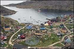
The buildings in Kangersuatsiaq are located on a small cape at the foot of some large mountain sections. Towards the south, the cape is delimited by a natural harbour with a sandy beach, and the distinctive church building is located in the middle of the cape as a landmark for the settlement, on top of a mountain knoll. From here, the new buildings extend up through an east-west running hollow featuring self-builder’s houses south of the cemetery, up towards a north-south running hollow where the settlement’s helistop and dump are located.
Provisions and subareas
The general provisions apply to all subareas of the municipalities in towns, settlements and open country areas. The provisions are general and do not consider the local conditions in the subareas.
General provisions of the Town Plan
The overall provisions for each subarea are the basis for the municipality"s granting of area allotments and building permits.
The aim is to maintain the current level of service and housing. Further urban development is to take place within the existing settlement area.
In addition to strengthening the existing basis for business, the goal is to develop new business opportunities, based on the resources of the sea, including sustainable fishing, sealing and whaling, within existing subareas. Tourism is also seen as holding development potentials. The settlement is well-functioning, and its own initiatives in cleaning are to be backed by proper technical solutions, infrastructure and sufficient supply systems. A number of buildings are in need of rehabilitation or redevelopment, which should be carried out carefully with due consideration of the settlement’s location in the landscape and its well-kept preservation-worthy buildings.
In the last forty years, there has been a decline in the population of about 28% from a population of 217 in 1980 to a population of 157 in 2017. The years did, though, see major fluctuations in the population, which peaked in the 1990s at around 250 inhabitants. The decrease is probably due to the smaller population of Greenland halibut and the closure of the settlement’s production facility.
Housing mainly consists of detached single-family houses. From 1990 to 2000, when the population growth peaked, a new residential area was established east of the port, and it has some remaining capacity. The new residential area is located on a relatively steep cliff towards the port entrance, rendering it quite exposed to ships calling on Kangersuatsiaq. Consequently, it is important that the location and layout of new houses match the overall impression conveyed by the port, the KNI buildings, the beach and the church.
The port is located in the central part of the settlement along with the other public and private service functions. The port is a port of call with a jetty of 4.5 metres and a water depth of 1.6 to two metres. Naalakkersuisut has designated an approx. 900 meters long y-shaped port authority area between Kangersuatsiaq and the island, which also includes a piece of the landing quay.
South of the settlement is the industrial area, which houses the former production facility. There is plenty of remaining capacity in the area if new companies should want to set up there.
Jobs in the settlement are related to Pilersuisoq, Saattuaq A/S/Upernavik Seafood , Avannaata Kommunia, Nukissiorfiit and health services. In addition, business is primarily dependent on sealing, whaling and fishing, despite of a stagnation. Nonetheless, fish are still traded at Kangersuatsiaq. Tourism also generates jobs. By 2015, the unemployment rate in the rural areas of the Upernavik district was 10.9% overall. This is slightly higher than Upernavik, where the unemployment rate was 9.3%. Likewise, it is slightly higher than both the municipal average (9.1%) and the national average (9.1%).
In the town plan, the remaining capacity for industry and port facilities is estimated at 3,000 m2.
The settlement's primary school, Juaap Atuarfia, is located in the centre area near the harbour and has approx. 30 students in the 1st to 9th grade. Form 10 is handled by the school in Upernavik. A new school was constructed in 2011.
Kangersuatsiaq includes nine preservation-worthy buildings: B-59, B-64, B-65, B-69, B-70, B-110 (the church), B-112 (the school), B-195 and B-42, all of which are located in the centre area.
Kangersuatsiaq also includes a library.
